Water Monitoring
VLAWMO maintains several monitoring programs to support the management of key lakes and ditches. Water quality sampling occurs bimonthly from May through September.
Water monitoring data gives us important insight into the health of our watershed. This data is also used to guide projects and seek grants for watershed improvements, inform water management plans, compare to state standards, and observe how local waterbodies change over time.
Water Monitoring Reports
Visit our resource library for the full water monitoring reports and their summaries.
Phosphorus is a naturally occurring nutrient and a main driver of algae growth. One pound of phosphorus can produce up to 500 pounds of algae. Increased algae levels create low oxygen and poor light penetration in lakes, reducing quality of fish and wildlife habitat.
High phosphorus levels determine whether the water looks like pea soup or an aquarium. Excessive algae can produce foul smells and toxins harmful to humans and pets. To prevent this, it’s important to keep sediment and nutrients on the landscape and out of waterbodies.
Chlorophyll-a measurements are used as an indicator of photosynthetic activity and algal biomass. Waters with high levels of nutrients from fertilizers, septic systems, improper sewage treatment, and urban runoff may have high concentrations of chlorophyll-a and excess amounts of algae. Chlorophyll-a works together with phosphorus to drive algae growth. Staff observe the relationship between the two when reviewing the data.
Algae adds oxygen to the water as a by-product of photosynthesis, but too much algae can contribute to decreased levels of dissolved oxygen, which is needed for aquatic life. Excessive algae increases the risk of undesired odors and blue-green algae blooms, which can be toxic.
A Secchi disk is a flat metal disk that is lowered into the water until it can no longer be seen. The depth where the disk disappears, called the Secchi depth, is a measure of the transparency of the water.
Poor transparency means there’s extra nutrients, algae, sediment, or other debris in the water. Transparency is the most basic indicator to assess risks for most lake uses, and informs us of potential issues that could occur further downstream. Transparency can be influenced by pollutants or sediment draining into the lake from the surrounding land area or by existing sediments recirculating from the lake bottom.
Chloride is a common ingredient in salt de-icers and home water softening. Chloride is a permanent pollutant to water quality, and it takes only one teaspoon of salt to pollute five gallons of water. It is toxic to aquatic life and interrupts lake temperature and nutrient cycles.
Chloride poses threats to freshwater and even drinking water supplies. There is no economical way to remove it. VLAWMO currently has no waterbodies impaired for chloride, but some lakes show upward trends. Lake chloride levels can decline as water flushes through, but the chloride will carry through to rivers, other lakes, or groundwater.
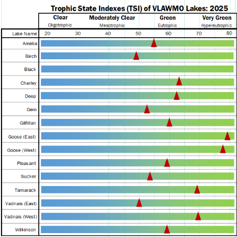
The Trophic State Index (TSI) is a classification for lakes according to their nutrient levels. Different classifications pertain to the amount of productivity occurring in the water. While nutrients are naturally occurring and needed in the aquatic ecosystem, excess nutrients are a form of water pollution that create imbalances and impairments in the aquatic ecosystem. Water resource managers use an equation using phosphorus, Secchi disk, and Chlorophyll-a data to create a TSI rating.
- Lakes with lower TSI ratings (below 30) are generally low productivity, clear, and best for water sports.
- Lakes with medium TSI ratings are generally support a range of aquatic habitat including fish, plants, algae, insects, and other wildlife.
- Lakes with a high TSI (above 71) are considered to be high in biological productivity and likely have an excess of nutrients. This can create a range of conditions including an algae-dominated, turbid water state.
Over half of Minnesota's waterbodies are listed as impaired by the Minnesota Pollution Control Agency (MPCA). Many of these are impaired for high nutrient levels, and the VLAWMO watershed has several lakes listed with this status.
Conductivity: Conductivity is a measure of water's ability to pass an electrical current. A high conductivity indicates dissolved salts or other inorganic chemicals that conduct electrical current. Water resource managers keep track of a conductivity baseline for each waterbody to allow for a comparison if significant changes occur.
Temperature: Water temperature can impact which kinds of organisms live in waterbodies. The rate of chemical reactions generally increases at higher temperatures, as warmer water holds less dissolved oxygen, which is needed for aquatic life. Impervious surfaces such as parking lots can contribute to hotter lakes and wetlands, such as stormwater runoff hitting hot pavement on a summery day. This runoff enters lakes, streams, or wetlands warmer than if it went through soil or green infrastructure such as a raingarden.
Nitrogen: Excess nitrogen can cause an overstimulation of growth in algae or aquatic plants. High nitrogen levels can pose risks for nitrate contamination in shallow groundwater.
pH: pH is a measure of how acidic or basic the water is. It tells us how nutrients or metals can be dissolved in a given waterbody, and what the waterbody can make available (i.e. phosphorus) for aquatic life. Water resource managers keep track of pH baselines and look for sudden changes that could provide clues to other issues.
Macroinvertebrates: Macroinvertebrates are organisms that lack a backbone and are large enough to be seen with the naked eye. Examples include dragonfly and mayfly nymphs, crayfish, scuds, clams, snails, and aquatic worms. Different species of macroinvertebrates have different sensitivities to pollution or imbalances in the aquatic ecosystem. Water resource managers look to macroinvertebrates for hints at short and long-term trends in the aquatic environment, and to compliment chemistry data.
VLAWMO conducts special monitoring efforts based on current projects and issues occurring in the watershed. Examples of special monitoring include:
- Bacteria source study to assess source of storm-event impairment on Lambert Creek.
- Wet weather monitoring for projects such as sand-iron and biochar filters.
- Assessing the impact of the "first flush," the 5-minute period of stormwater runoff immediately following a rain event.
- Water quality tests on specific waterbodies with new treatment plans.
Visit our resource library for reports and more information.
Water Resources
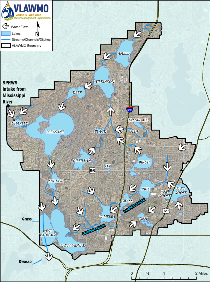
Surface flow in the VLAWMO watershed goes both north and south. Surface water generally flows into East Vadnais Lake as the receiving basin, with the exception of Gem Lake and West Vadnais Lake.
Gem Lake is an independent subwatershed within the VLAWMO watershed. It has no surface connection to other waterbodies.
West Vadnais Lake is not connected to East Vadnais Lake, and it contains engineered connections to Grass Lake (West) and Lake Owasso (Southwest), which are located within the Ramsey-Washington Metro Watershed District.
Charley Lake receives water from the Mississippi River through the Saint Paul Regional Water Services (SPRWS). East Vadnais Lake serves as the final reservoir in a chain of lakes before the water is sent to the treatment facility to provide drinking water for the City of Saint Paul and surrounding communities.
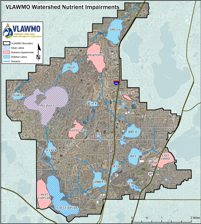
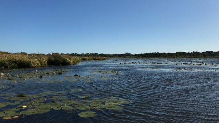
With the exception of East Vadnais Lake and Pleasant Lake, most of the lakes in the VLAWMO watershed are classified as shallow lakes. Shallow lakes are more influenced by their landscape surroundings than deep lakes. Typically under 20 feet in depth, their ecology can sway between healthy and impaired states.
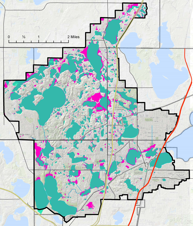
Over half of Minnesota's waterbodies are listed as impaired by the Minnesota Pollution Control Agency (MPCA). An impairment listing comes from data on nutrient levels, turbidity, and various other readings, and compares them to a standard. Watershed organizations such as VLAWMO are charged with the task of helping lead communities to improve Minnesota's prized water resources. View the map below to see lakes that are listed as impaired in the VLAWMO watershed. Read more about water quality data and state standards in the Water Monitoring section below.
Characteristics of a shallow lake include:
- Typically under 20 feet in depth. More influenced by their landscape surroundings than deep lakes.
- Sunlight reaches the bottom of most of the lake bed, allowing aquatic plants to grow.
- Aquatic plants serve as a stabilizer for a shallow lake bed, holding sediment and nutrients in the sediment and plant matter.
- Water in shallow lakes mixes faster and more frequently due to wind and shallow water.
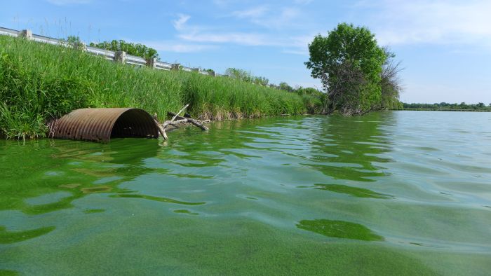
- Shallow lakes are prone to eutrophication, the movement of nutrients from the landscape to a low-lying basin. If excessive, shallow lakes can tip into a turbid water state that's dominated by algae instead of aquatic plants. The algae consumes the light and nutrients and prevents plants from growing, keeping the lake stuck in this state. This changes the aquatic habitat including fish, insects, and birds, and risks impairments for other waterbodies downstream.
- Shallow lakes are dynamic, with water levels that historically ebb and flow with the water table. Their water quality can sway between healthy and impaired states, but it is much harder to bring a shallow lake from impaired to healthy than it is healthy to impaired.
Characteristics of deep lakes include:
- Typically deeper than 20 feet in depth.
- Contain stratification - changing temperatures and water chemistry that occur at different depths.
- Slower mixing due to more water being less influenced by wind and wave action.
- Aquatic plants concentrate in shallower areas where light can reach the bottom.
- Areas too deep for aquatic plants contain sediment and nutrients from shallow areas and water column.
- Generally more stable water levels.
- Can also become impaired but use different water quality standards than shallow lakes.
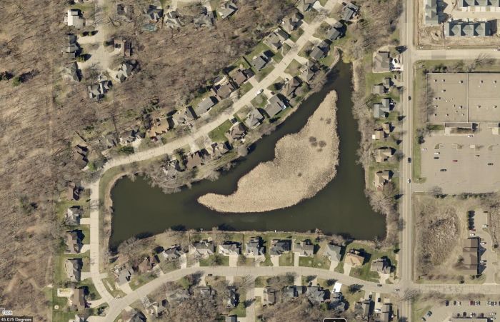
Can you tell which lake is clean and which is impaired?
The VLAWMO watershed contains over 500 wetlands and several ditches. Visit the History page for more information on ditches within the watershed.
VLAWMO's many wetlands are a valuable resource. They act as sponges that provide water storage, filtration and infiltration, and help to protect downstream waterbodies such as East Vadnais Lake. But with fewer wetlands and more stormwater generated from hard surfaces such as streets and rooftops, our wetlands work harder than they used to. Efforts to slow down, store, and infiltrate stormwater close to where it falls help support the longevity, storage capacity, and function of our remaining wetlands.
The map below illustrates where wetlands are found in the VLAWMO watershed.
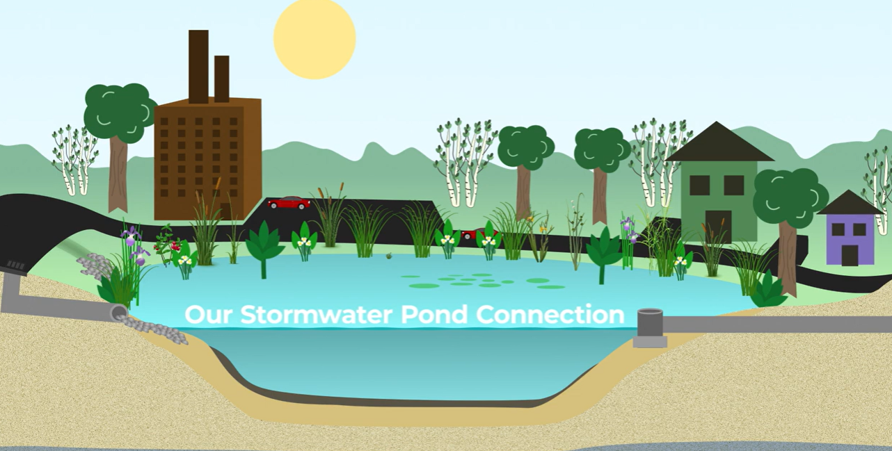
Stormwater ponds can be an attractive neighborhood feature, but their value goes beyond aesthetics. While some stormwater ponds may be a remnant of a former wetland modified before wetland policies were in place, most were engineered as part of a neighborhood development. Designed with an inlet, outlet, and overflow, stormwater ponds connect to a storm drain or a ditch network that leads to a larger downstream waterbody.
What are stormwater ponds?
In a built landscape, stormwater ponds are tools to balance valuable water storage that is often lost to development. They provide basic water quality treatment spaces for sediment and contaminants to settle out of stormwater runoff before traveling to a downstream waterbody. Over time, stormwater ponds are expected to fill in with sediment and nutrients from the surrounding landscape, which can change the pond's appearance. These changes can be concerning to witness, but they are evidence that a pond is fulfilling its design of protecting a downstream waterbody such as East Vadnais Lake. Fountains are a common feature installed to help stormwater ponds circulate water and air, and they can provide some aesthetic improvements when a pond experiences algae blooms. VLAWMO does not participate in or fund fountains.
Click here to watch a brief overview of stormwater ponds from the Anoka Conservation District.
What's the challenge with stormwater ponds?
Sedimentation and nutrient inputs (eutrophication) are natural processes, but the built environment and human habits can speed them up and increase inputs into stormwater ponds and wetlands. Climate and landscape changes mean that stormwater ponds and wetlands receive more stormwater runoff in a shorter span of time, but their holding capacity remains limited. Stormwater ponds have an expected lifespan before they require maintenance, and municipalities maintain a certain percentage of their owned stormwater ponds annually. VLAWMO does not own any stormwater ponds but instead supports and guides communities in maintenance and understanding of them according to the MS4 Permit.
We can all support the valuable services that our stormwater ponds provide through mindful home and yard practices. Visit What We Do to learn more or check out the resources page for ways to support stormwater ponds, wetlands, and lakes.
Stormwater ponds and salt
Stormwater pond quality can be impacted by de-icing salts in runoff. Research has shown that salt accumulation can exacerbate algae blooms in storm ponds. Acetate de-icers are a non-chloride alternative, but they contain nutrients such as phosphorus, which also encourage algae blooms. For this reason, both salt products and acetates should be used sparingly and according to MPCA Smart Salting practices. Sand and grit are alternative options for winter traction in cold temperatures, and should be swept up when ice is no longer present.
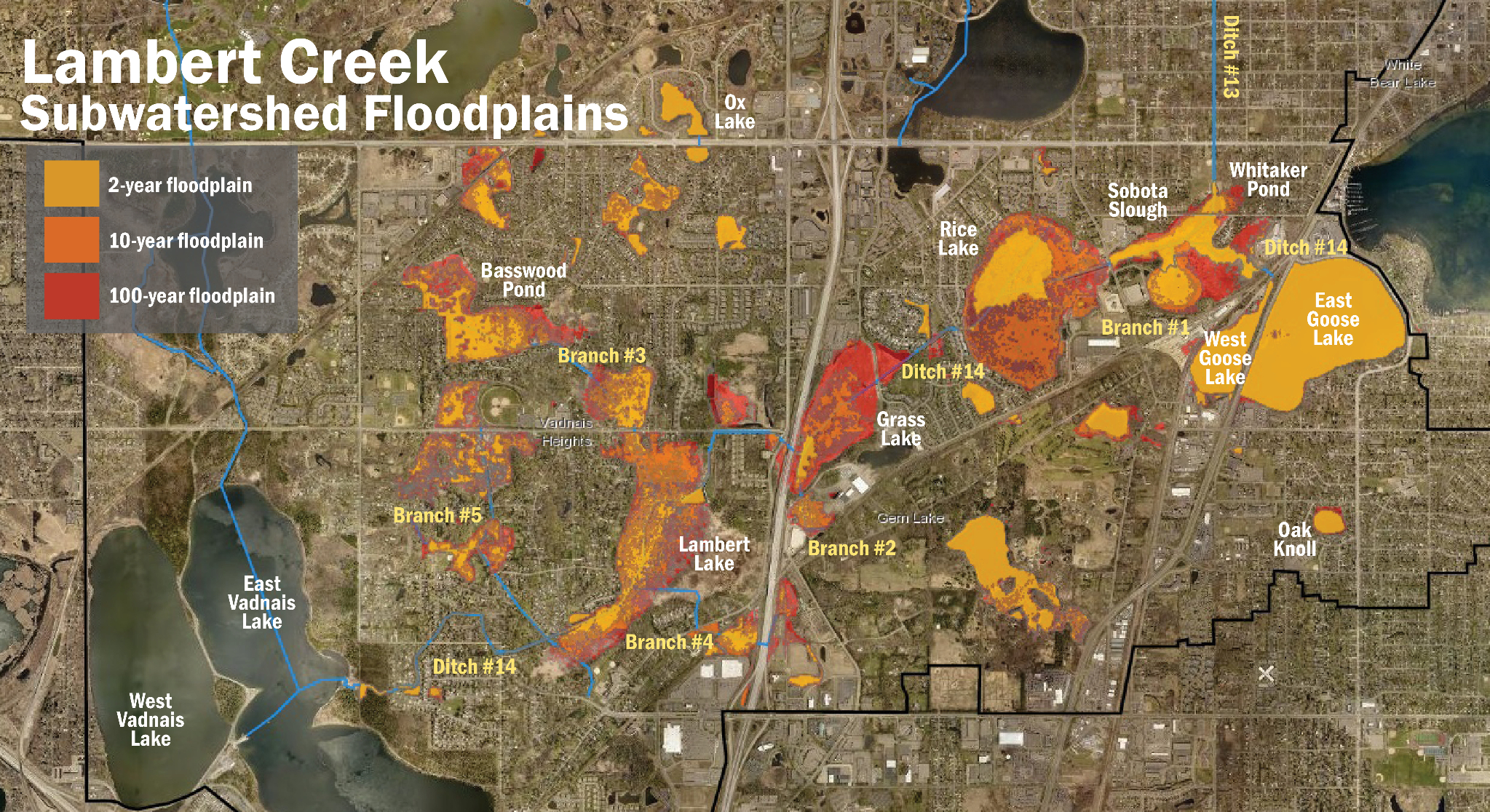
VLAWMO uses hydrology studies and stormwater modeling to guide local flood mitigation efforts. This work entails observing climate and precipitation trends, creating and maintaining surface water storage that was historically lost due to development, and helping communities adhere to floodplain boundaries when building and renovating. Visit the VLAWMO GIS Web Map for an interactive and detailed look at the watershed's floodplains and wetlands.
In 1994 VLAWMO completed a comprehensive wetland storage effort along Lambert Creek. This effort transformed and restored several areas of a former agricultural ditch (Ditch 14) into a series of valuable wetland storage areas. The effort focused on Whitaker Pond, Rice Lake, Grass Lake, and Lambert Lake, and improved floodplain access in these areas. Today this system is maintained and monitored in partnership between VLAWMO and its member communities. While the Lambert Creek drainage system still contains areas of former agricultural ditch and has opportunities for improvement, hydrology studies show that it is functioning within the expectations of Minnesota ditch laws.